AP Transit has launched an advanced 3D map of the New York City subway that visualizes real-time train movement across the entire system. The app combines live train tracking, interactive 3D mapping, home screen widgets, transfer maps, and detailed station exit maps to help users navigate NYC more clearly and efficiently. Designed for commuters, residents, and visitors, AP Transit transforms complex subway data into an intuitive, real-world navigation experience.
NY, United States, 29th Dec 2025 – AP Transit, a next-generation transit mapping application, has officially launched a powerful 3D map of the New York City subway, combining real-time train movement, smart widgets, and detailed station navigation into a single, intuitive experience.
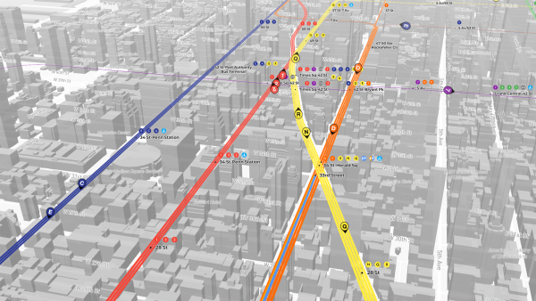
The new 3D subway map visualizes live train movement across all NYC subway lines, allowing users to see trains moving through tunnels and stations in real time. This interactive approach transforms how riders understand the subway system, making daily commutes, transfers, and trip planning faster and more transparent.
Unlike traditional flat transit maps, AP Transit’s 3D environment provides spatial clarity, helping users better understand complex station layouts and line intersections across New York City.
Key Features of AP Transit
- Real-Time Train Movement
Live visualization of subway trains moving across the NYC system, powered by real-time transit data. - 3D NYC Subway Map
A fully interactive three-dimensional map that offers a clearer view of routes, tunnels, and station relationships. - Home Screen Widgets
Smart widgets for iOS and Android that show nearby lines, live arrivals, and service status directly on the home screen. - Transfer Map
A dedicated subway transfer map that clearly displays connections between lines, reducing confusion at complex stations. - Station Exit Map
Detailed exit maps that help riders choose the correct station exit for their destination, saving time above ground.
AP Transit is designed for New York residents, commuters, and visitors who want more than a basic subway map. By combining real-time data, 3D visualization, and station-level navigation tools, the app bridges the gap between raw transit information and real-world movement through the city.
The launch of the 3D subway map marks a major step forward in urban mobility tools, setting a new standard for how large metropolitan transit systems can be explored and understood.
AP Transit is available now, offering a smarter, more visual way to navigate the New York City subway.
Media Contact
Organization: AP Transit
Contact Person: Alexander
Website: https://aptransit.co
Email: Send Email
City: New York
State: NY
Country:United States
Release id:39624
The post AP Transit Launches Advanced 3D New York City Subway Map With Real-Time Train Tracking appeared first on King Newswire. This content is provided by a third-party source.. King Newswire makes no warranties or representations in connection with it. King Newswire is a press release distribution agency and does not endorse or verify the claims made in this release. If you have any complaints or copyright concerns related to this article, please contact the company listed in the ‘Media Contact’ section